CITY PROFILE: Pleasant Hill

Pleasant Hill is a small suburban community of about 30,000 people, bordered by Lafayette to the west, Walnut Creek to the south, Concord to the east, and Martinez to the north (approximately). The higher value areas tend to be those close to Lafayette, Walnut Creek, and Martinez with areas close to Martinez recently rising relative to other areas as that town becomes more popular.
Highway 680 bisects Pleasant Hill along a north/south axis, with most of the residential areas and the main commercial strip, Contra Costa Blvd, on the west side. Ironically the largest retail complex, Sunvalley Mall, is west of the freeway surrounded by Pleasant Hill homes, but within the City of Concord – the only significant part of Concord west of 680.
Pleasant Hill is the home of Diablo Valley College (DVC), one of the highest rated community colleges in the State and a major feeder-school for Cal Berkeley. Adjacent to the College is College Park High School, which serves most of Pleasant Hill, significant portions of Martinez and Walnut Creek, along with a few Lafayette neighborhoods. Pleasant Hill elementary and middle schools are well regarded, generally better than Concord, but less than Lafayette.
Pleasant Hill was farmland prior to WWII, then it grew rapidly postwar and through the early 1960s, prior to incorporating as a City. The City Government has traditionally limited development and until recently discouraged the development of the confused downtown. Before the late 1970s, the downtown was dominated by a drive-in theatre, a large car lot, and rundown buildings. But recently Pleasant Hill has developed an interesting modern retail and entertainment presence offering a less congested alternative to Walnut Creek.
There is a nine-hole public golf course and the popular Contra Costa Country Club. Pleasant Hill has the largest public library in the county and a recently remodeled YMCA. The new downtown (image above) features a modern theater complex, many restaurants, and a myriad of large and small stores, with reasonable parking. To the north, Contra Costa Blvd. is a vibrant retail strip with several large centers, then tapering into small warehouse/retail approaching Pacheco. The old Montgomery Wards center on the east side of the freeway has been substantially redeveloped into a modern center anchored by Kohls (clothing and home goods).
HOUSING:
Less than one percent of the homes in Pleasant Hill predate WWII, but by 1950 about 10% of existing homes had been built. The 1950s saw an explosion of building in Pleasant Hill with nearly a third of the current housing stock built in that decade. Building slowed down during the 1960s and 1970s, but exploded again in the 1980s, with a significant number of townhomes and condos being built. Roughly 95 percent of all homes had been built by 1990, with only a few infill developments being built since.

Though there are definitely higher and lower value neighborhoods, there is little crime in Pleasant Hill and most neighborhoods are considered safe. Value distinctions are mostly based on the quality/size of the homes and schools.
Gregory Gardens, especially the eastern area near Contra Costa Blvd is among the least expensive neighborhoods, along with Sherman Acres and Fair Oaks to the east of 680, and the pocket of older homes north of Ellinwood (Pleasant Hill Manor and Rancho Monte). The homes east of DVC across from Sunvalley shopping center are relatively affordable. Homes that are east of Contra Costa Blvd, or just to the west tend to be the most affordable, especially in neighborhoods served by Ygnacio Valley High School.
The most expensive parts of Pleasant Hill tend to be the farthest west near Lafayette in neighborhoods such as Grayson Woods, Shannon Hills, and Poets’ Corner. These homes tend to be larger and newer. Though Poets Corner was an early development, the homes are desirable and many have been significantly expanded. Attendance to highly rated Strandwood Elementary School is a value positive.
The Neighborhood map linked above shows the build dates by decade of the homes in various neighborhoods, and shows the locations of neighborhoods discussed above.
HISTORY:

A community leader described Pleasant Hill on the eve of its incorporation in 1961 as "a dozen subdivisions looking for unity." Pleasant Hill had previously been a loosely knit farming community on land first inhabited by the Ohlone Indians and later by Mexican rancho owners.
In the 1890s Pleasant Hill began to be identified as the hub of a growing farming community with good soil and climate. About twenty farms in the area, of various sizes, helped provide a robust agricultural economy which drove the steady growth of local commerce. In 1891 the Central Pacific Railroad built a rail-line through the Diablo Valley, which passed through Pleasant Hill. In 1911, the Sacramento Northern electric railroad was built through Pleasant Hill.
The community lacked a central unifying element, so businesses grew sporadically along Contra Costa Boulevard. Pleasant Hill was named in 1865, as it developed as transportation hub providing access to the Diablo Valley.
Telephone lines that came to Pleasant Hill in 1906, and mail service began around 1912. Federal funding provided a canal, bringing water to agriculture in the early 1940s.
Post WWII, the area consisted of small farms and large ranches. Post war brought a sudden expansion. As industry flourished in the general area, workers sought housing in Pleasant Hill, and subdivisions began in several areas.
Incorporation came late for Pleasant Hill. In 1959, Walnut Creek looked to annex it but was turned down by the voters. In 1960, Concord made a bid for certain commercial districts, and they, too, were voted down. It was not until 1961, with a population of 19,800, that incorporation was accepted by voters. The new city provided minimum services without additional property tax.
Growth has been unpopular in Pleasant Hill. The population has hovered around 30,000 since 1975; the City Council passed an anti-growth initiative in June 1986. It was not until recently that redevelopment began in the downtown area, and newer housing has been approved.
SCHOOLS:
Children in Pleasant Hill attend schools in the Mt. Diablo School District, where some of the schools are in common with Martinez, Concord, and Pacheco. While overall the Mt. Diablo School District has seen a decline, most of the schools serving Pleasant Hill children are among the best in that district.
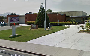
Most kids attend College Park (image right) in the Mt. Diablo School District, where the 2013 API rating is 817; however, a few neighborhoods attend low rated Ygnacio Valley High School with a 2013 API rating of 655. Pleasant Hill High School was closed in the late 1970s, when the district added the new Northgate High in Walnut Creek. Many neighborhoods were absorbed into College Park's territory, but those which were assigned to Ygnacio suffered value declines relative to other parts of town. Some of this has been redressed recently with most areas on the west side of Highway 680 now attending College Park.
School Rankings
College Park High School - API 817
Ygancio Valley High School - API 655
Valley View Middle School - API 805
Pleasant Hill Middle School - API 813
Sequoia Middle School - API 876
Sequoia Elementary - API 946
Strandwood Elementary - API 938
Pleasant Hill Elementary - API 887
Valhalla Elementary - API 869
Gregory Gardens Elementary - API 823
Fair Oaks Elementary - API 722
High Schools Map - Shows State API Score by Location
(Above 900 is excellent - Under 700 is scary)